The newest drawer to Conditions on the Ground has been added!
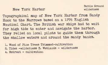
After hundreds of years of dredging and filling New York Harbor no longer resembles the place the Lenape lived or the place the first explores or the British fleet encountered. The Atlantic meets the harbor at Sandy Hook. British boats bobbed around that area before entering the Harbor. To enter boats had to wait for high tide so the waters were deep enough to navigate. Local pilots were hired to help guide boats through the shallow waters and past submerged sand banks off the coast of Brooklyn and Staten Island.